
Hohenkammer topographic map
Interactive map
Click on the map to display elevation.
About this map
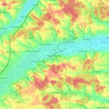
Name: Hohenkammer topographic map, elevation, terrain.
Location: Hohenkammer, Landkreis Freising, Bavière, 85411, Allemagne (48.38805 11.49262 48.46132 11.56488)
Average elevation: 1,578 ft
Minimum elevation: 1,450 ft
Maximum elevation: 1,729 ft
Other topographic maps
Click on a map to view its topography, its elevation and its terrain.
Ottenburg
Allemagne > Bavière > Landkreis Freising
Ottenburg, Eching, Landkreis Freising, Bavière, 85386, Allemagne
Average elevation: 1,562 ft