Geolocate

Juniper topographic map

Click on the map to display elevation.

About this map

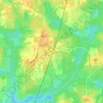
Name: Juniper topographic map, elevation, terrain.

Location: Juniper, Gadsden County, Florida, 32330, United States (30.52269 -84.77325 30.56269 -84.73325)

Average elevation: 220 ft

Minimum elevation: 154 ft

Maximum elevation: 289 ft

Gadsden County trails, hiking, mountain biking, running and outdoor activities

Other topographic maps

Click on a map to view its topography, its elevation and its terrain.

Gretna

United States > Florida > Gadsden County

Average elevation: 269 ft

Lake Tallavana

United States > Florida > Gadsden County

Average elevation: 194 ft

Greensboro

United States > Florida > Gadsden County

Average elevation: 246 ft

Gear up for your next adventure:

🔊Portable Camp Speaker - Music and alerts at camp
🧥Waterproof Jacket for Hiking - Breathable and rugged rain jacket for outdoor excursions
🏔️Mountain Trail Maps - High‑detail maps for popular peaks
📶Vehicle Signal Boosters - Improve reception in rural areas while driving to trailheads
🗺️Topographic Maps - Detailed topo maps for hiking, exploring and outdoor navigation

As an Amazon Associate, this site earns from qualifying purchases at no extra cost to you.