
Thank you for supporting this site ❤️
Make a donation
Make a donation
Gear up for your next adventure:
As an Amazon Associate, this site earns from qualifying purchases at no extra cost to you.
Rayaa Masaida topographic map
Click on the map to display elevation.
Thank you for supporting this site ❤️
Make a donation
Make a donation
Gear up for your next adventure:
As an Amazon Associate, this site earns from qualifying purchases at no extra cost to you.
About this map
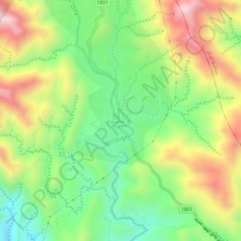
Name: Rayaa Masaida topographic map, elevation, terrain.
Location: Rayaa Masaida, Al Aydabi, Jazan Province, Saudi Arabia (17.35666 43.05354 17.39666 43.09354)
Average elevation: 3,330 ft
Minimum elevation: 2,359 ft
Maximum elevation: 4,669 ft
Thank you for supporting this site ❤️
Make a donation
Make a donation
Gear up for your next adventure:
As an Amazon Associate, this site earns from qualifying purchases at no extra cost to you.
Other topographic maps
Click on a map to view its topography, its elevation and its terrain.