Geolocate

Pesquería topographic map

Click on the map to display elevation.

About this map

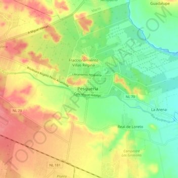
Name: Pesquería topographic map, elevation, terrain.

Location: Pesquería, Nuevo León, 66650, Mexico (25.74514 -100.09206 25.82514 -100.01206)

Average elevation: 1,129 ft

Minimum elevation: 1,014 ft

Maximum elevation: 1,250 ft

Gear up for your next adventure:

🏫Relief Map Kits - Hands-on tools for teaching landforms and elevation
🛠️Backpacking Tool Kit - Essential toolkit for outdoor repairs
🥩Freeze-Dried Meals - Nutritious and lightweight food for remote expeditions
🎒Outdoor Daypacks - Lightweight backpacks designed for carrying maps and essential gear
📡Handheld GPS Device - Reliable handheld GPS for outdoor navigation

As an Amazon Associate, this site earns from qualifying purchases at no extra cost to you.