Geolocate

Parchment topographic map

Click on the map to display elevation.

About this map

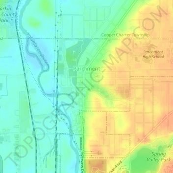
Name: Parchment topographic map, elevation, terrain.

Location: Parchment, Kalamazoo County, Michigan, 49004, United States (42.31778 -85.58131 42.33279 -85.55063)

Average elevation: 801 ft

Minimum elevation: 745 ft

Maximum elevation: 866 ft

Kalamazoo County trails, hiking, mountain biking, running and outdoor activities

Other topographic maps

Click on a map to view its topography, its elevation and its terrain.

Hogset Lake

United States > Michigan > Kalamazoo County

Average elevation: 863 ft

Milwood

United States > Michigan > Kalamazoo County > Kalamazoo > Milwood

Average elevation: 837 ft

Comstock

United States > Michigan > Kalamazoo County

Average elevation: 814 ft

Gull Lake

United States > Michigan > Kalamazoo County

Average elevation: 892 ft

Oakwood

United States > Michigan > Kalamazoo County > Kalamazoo

Average elevation: 899 ft

Gear up for your next adventure:

🔥Camping Stove - Portable stove for camping and backcountry cooking
🍳Camping Cook Set - Complete cookware for outdoor meals
📡Handheld GPS Device - Reliable handheld GPS for outdoor navigation
🎒Hydration Pack - Hands‑free water reservoir for long hikes
🕶️GPS Smartphone Mount - Secure mount for phone navigation

As an Amazon Associate, this site earns from qualifying purchases at no extra cost to you.