
Make a donation
Gear up for your next adventure:
As an Amazon Associate, this site earns from qualifying purchases at no extra cost to you.
Patalanga topographic map
Click on the map to display elevation.
Make a donation
Gear up for your next adventure:
As an Amazon Associate, this site earns from qualifying purchases at no extra cost to you.
About this map
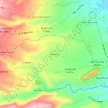
Name: Patalanga topographic map, elevation, terrain.
Location: Patalanga, Otavalo, Imbabura, 100208, Ecuador (0.24214 -78.31707 0.28214 -78.27707)
Average elevation: 8,514 ft
Minimum elevation: 8,120 ft
Maximum elevation: 8,976 ft
Make a donation
Gear up for your next adventure:
As an Amazon Associate, this site earns from qualifying purchases at no extra cost to you.
Other topographic maps
Click on a map to view its topography, its elevation and its terrain.
Lago San Pablo
Ecuador > Imbabura > Otavalo > Otavalo
El lago San Pablo (conocido también como Imbacocha) es un cuerpo de agua ubicado en la provincia de Imbabura, Ecuador, a una altitud de 2 700 metros sobre el nivel del mar. Posee un área de 3,5 x 2,2 km que cubren alrededor de 583 hectáreas y una profundidad aproximada de 83 m.
Average elevation: 8,776 ft