
Make a donation
Gear up for your next adventure:
As an Amazon Associate, this site earns from qualifying purchases at no extra cost to you.
Lethbridge topographic map
Click on the map to display elevation.
Make a donation
Gear up for your next adventure:
As an Amazon Associate, this site earns from qualifying purchases at no extra cost to you.
Lethbridge
Its high elevation of 929 m (3,048 ft) and close proximity to the Rocky Mountains provides Lethbridge with cooler summers than other locations in the Canadian Prairies. These factors protect the city from strong northwest and southwest winds and contribute to frequent chinook winds during the winter. Lethbridge winters have the highest temperatures in the prairies, reducing the severity and duration of winter cold periods and resulting in fewer days with snow cover. The average daytime temperature peaks by the end of July/beginning of August, when it reaches 26.4 °C (79.5 °F). The city's temperature reaches a maximum high of 35.0 °C (95.0 °F) or greater on average once or twice a year.
Make a donation
Gear up for your next adventure:
As an Amazon Associate, this site earns from qualifying purchases at no extra cost to you.
About this map
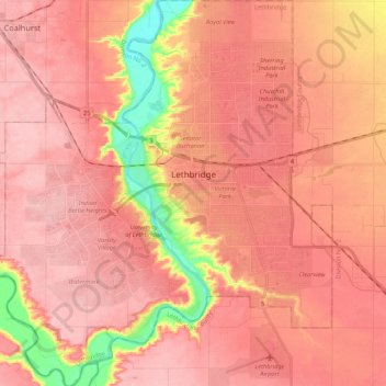
Name: Lethbridge topographic map, elevation, terrain.
Location: Lethbridge, Alberta, Canada (49.61885 -112.94967 49.75651 -112.75663)
Average elevation: 2,979 ft
Minimum elevation: 2,674 ft
Maximum elevation: 3,110 ft
Make a donation
Gear up for your next adventure:
As an Amazon Associate, this site earns from qualifying purchases at no extra cost to you.