Geolocate

Caerwent topographic map

Click on the map to display elevation.

About this map

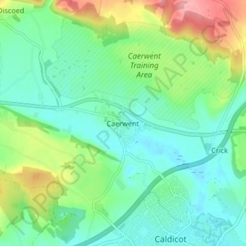
Name: Caerwent topographic map, elevation, terrain.

Location: Caerwent, Monmouthshire, Wales, NP26 5JJ, United Kingdom (51.59006 -2.78431 51.63006 -2.74431)

Average elevation: 125 ft

Minimum elevation: 7 ft

Maximum elevation: 410 ft

Other topographic maps

Click on a map to view its topography, its elevation and its terrain.

Wye Valley

United Kingdom > Wales > Monmouthshire

Average elevation: 548 ft

Chepstow Castle

United Kingdom > Wales > Monmouthshire > Chepstow

Average elevation: 174 ft

Penallt

United Kingdom > Wales > Monmouthshire

Average elevation: 571 ft

Crucorney

United Kingdom > Wales > Monmouthshire

Average elevation: 974 ft

Blorenge

United Kingdom > Wales > Monmouthshire > Govilon

Average elevation: 1,293 ft

River Monnow

United Kingdom > Wales > Monmouthshire

Average elevation: 564 ft

Llanbadoc

United Kingdom > Wales > Monmouthshire

Average elevation: 256 ft

Raglan Castle

United Kingdom > Wales > Monmouthshire > Raglan

Average elevation: 194 ft

River Monnow

United Kingdom > Wales > Monmouthshire

Average elevation: 564 ft

Gear up for your next adventure:

🎁Geography Themed Gifts - Unique gift ideas for map lovers and geography enthusiasts
🏔️Mountain Trail Maps - High‑detail maps for popular peaks
📚USA Hiking Guide Books - Top trail guides and map books
🔋Solar Power Banks - Keep your GPS and phone charged in remote wilderness areas
🌡️Handheld Weather Meters - Measure wind, temp, and pressure for safe mountain travel

As an Amazon Associate, this site earns from qualifying purchases at no extra cost to you.