
Make a donation
Gear up for your next adventure:
As an Amazon Associate, this site earns from qualifying purchases at no extra cost to you.
Uyugan topographic map
Click on the map to display elevation.
Make a donation
Gear up for your next adventure:
As an Amazon Associate, this site earns from qualifying purchases at no extra cost to you.
Uyugan
Today's Isantonino farmer still could barely feed his family due to antiquated methods of farming dictated mainly by the topography of the land that at best is unsuitable to agriculture. Nevertheless, Uyugan was a leading producer of beef cattle and garlic prior to the global economy.
Make a donation
Gear up for your next adventure:
As an Amazon Associate, this site earns from qualifying purchases at no extra cost to you.
About this map
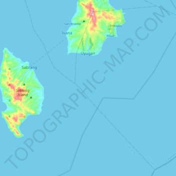
Name: Uyugan topographic map, elevation, terrain.
Location: Uyugan, Batanes, Cagayan Valley, 3903, Philippines (20.22697 121.92337 20.40891 122.12047)
Average elevation: 62 ft
Minimum elevation: -3 ft
Maximum elevation: 1,335 ft
Make a donation
Gear up for your next adventure:
As an Amazon Associate, this site earns from qualifying purchases at no extra cost to you.