
Río Pesquería topographic map
Interactive map
Click on the map to display elevation.
About this map
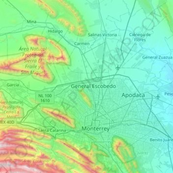
Name: Río Pesquería topographic map, elevation, terrain.
Location: Río Pesquería, García, Nuevo León, 66650, México (25.78180 -100.63710 25.83222 -100.05708)
Average elevation: 2,395 ft
Minimum elevation: 1,093 ft
Maximum elevation: 9,098 ft
Other topographic maps
Click on a map to view its topography, its elevation and its terrain.
Mesa de Pinos
México > Nuevo León > García
Mesa de Pinos, García, Nuevo León, México
Average elevation: 4,298 ft
El Fraile
México > Nuevo León > García > El Fraile
El Fraile, García, Nuevo León, 66023, México
Average elevation: 2,280 ft