
García topographic map
Interactive map
Click on the map to display elevation.
About this map
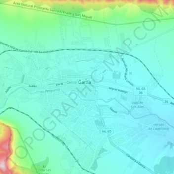
Name: García topographic map, elevation, terrain.
Location: García, Nuevo León, 66003, México (25.77219 -100.63310 25.85219 -100.55310)
Average elevation: 2,569 ft
Minimum elevation: 2,165 ft
Maximum elevation: 4,888 ft
Other topographic maps
Click on a map to view its topography, its elevation and its terrain.
Mesa de Pinos
México > Nuevo León > García
Mesa de Pinos, García, Nuevo León, México
Average elevation: 4,298 ft
Río Pesquería
México > Nuevo León > García
Río Pesquería, García, Nuevo León, 66650, México
Average elevation: 2,395 ft
El Fraile
México > Nuevo León > García > El Fraile
El Fraile, García, Nuevo León, 66023, México
Average elevation: 2,280 ft