Geolocate

Afton topographic map

Click on the map to display elevation.

About this map

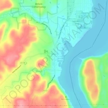
Name: Afton topographic map, elevation, terrain.

Location: Afton, Washington County, Minnesota, 55001, United States (44.88275 -92.80354 44.92275 -92.76354)

Average elevation: 804 ft

Minimum elevation: 666 ft

Maximum elevation: 1,030 ft

Washington County trails, hiking, mountain biking, running and outdoor activities

Gear up for your next adventure:

🎒Trail Energy Bars - High‑calorie bars for hiking energy
🚗GPS Dash Cams - Record your scenic drives through mountain passes and canyons
🥘Titanium Cookware - Durable, featherlight pots and pans for backpacking
🥾Men's Hiking Boots - Durable, waterproof footwear for rugged terrain and steep inclines
👟Trail Running Shoes - Lightweight shoes for trail runners

As an Amazon Associate, this site earns from qualifying purchases at no extra cost to you.