
Make a donation
Gear up for your next adventure:
As an Amazon Associate, this site earns from qualifying purchases at no extra cost to you.
Eagles Island topographic map
Click on the map to display elevation.
Make a donation
Gear up for your next adventure:
As an Amazon Associate, this site earns from qualifying purchases at no extra cost to you.
About this map
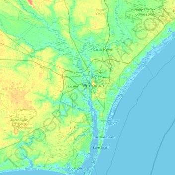
Name: Eagles Island topographic map, elevation, terrain.
Average elevation: 26 ft
Minimum elevation: -10 ft
Maximum elevation: 121 ft
Brunswick County trails, hiking, mountain biking, running and outdoor activities
Make a donation
Gear up for your next adventure:
As an Amazon Associate, this site earns from qualifying purchases at no extra cost to you.
Other topographic maps
Click on a map to view its topography, its elevation and its terrain.
Boiling Spring Lake
United States > North Carolina > Brunswick County > Boiling Spring Lakes
Average elevation: 46 ft
Make a donation
Gear up for your next adventure:
As an Amazon Associate, this site earns from qualifying purchases at no extra cost to you.
North Carolina Coastal Land Trust: Orton Plantation Holdings, LLC
United States > North Carolina > Brunswick County
Average elevation: 26 ft