
Thank you for supporting this site ❤️
Make a donation
Make a donation
Gear up for your next adventure:
As an Amazon Associate, this site earns from qualifying purchases at no extra cost to you.
Freyung topographic map
Click on the map to display elevation.
Thank you for supporting this site ❤️
Make a donation
Make a donation
Gear up for your next adventure:
As an Amazon Associate, this site earns from qualifying purchases at no extra cost to you.
About this map
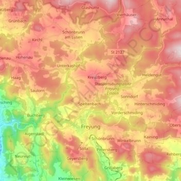
Name: Freyung topographic map, elevation, terrain.
Location: Freyung, Landkreis Freyung-Grafenau, Bavaria, 94078, Germany (48.77852 13.47725 48.88297 13.61228)
Average elevation: 2,280 ft
Minimum elevation: 1,280 ft
Maximum elevation: 3,028 ft
Thank you for supporting this site ❤️
Make a donation
Make a donation
Gear up for your next adventure:
As an Amazon Associate, this site earns from qualifying purchases at no extra cost to you.