Geolocate

Lawton topographic map

Click on the map to display elevation.

About this map

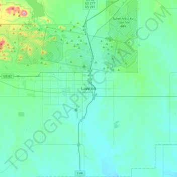
Name: Lawton topographic map, elevation, terrain.

Location: Lawton, Comanche County, Oklahoma, 73501, United States (34.44869 -98.55033 34.76869 -98.23033)

Average elevation: 1,184 ft

Minimum elevation: 1,001 ft

Maximum elevation: 2,451 ft

Comanche County trails, hiking, mountain biking, running and outdoor activities

Other topographic maps

Click on a map to view its topography, its elevation and its terrain.

Academic Hights

United States > Oklahoma > Comanche County > Lawton

Average elevation: 1,142 ft

Gear up for your next adventure:

🪄Magnetic Compass - Accurate compass for navigation
☀️Outdoor Sunscreen - High protection sunscreen for outdoor activities
🔦Compact Flashlight - Reliable flashlight for emergencies
🧭Pro Hiking Compasses - High-accuracy liquid-filled compasses for topographic orientation
🎒Day Hiking Backpack - Lightweight backpack perfect for day trips and outdoor adventures

As an Amazon Associate, this site earns from qualifying purchases at no extra cost to you.