Geolocate

Toledo topographic map

Click on the map to display elevation.

About this map

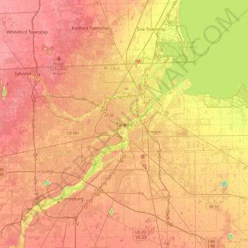
Name: Toledo topographic map, elevation, terrain.

Location: Toledo, Lucas County, Ohio, 43659, United States (41.49291 -83.69782 41.81291 -83.37782)

Average elevation: 620 ft

Minimum elevation: 466 ft

Maximum elevation: 702 ft

Lucas County trails, hiking, mountain biking, running and outdoor activities

Gear up for your next adventure:

🧭Orienteering Set - Complete compass and map reading kit
📚USA Hiking Guide Books - Top trail guides and map books
😴Insulated Sleeping Pads - Compact and warm pads for high-elevation camping
🧥Waterproof Jacket for Hiking - Breathable and rugged rain jacket for outdoor excursions
🛠️Backpacking Tool Kit - Essential toolkit for outdoor repairs

As an Amazon Associate, this site earns from qualifying purchases at no extra cost to you.