Geolocate

Maasin topographic map

Click on the map to display elevation.

About this map

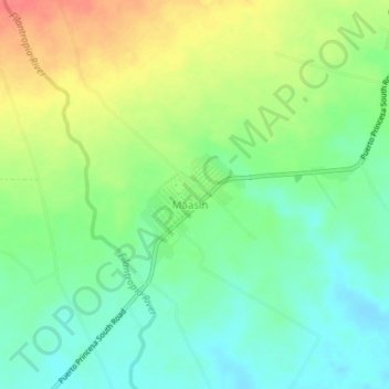
Name: Maasin topographic map, elevation, terrain.

Location: Maasin, Palawan, Mimaropa, Philippines (8.87359 117.92355 8.91359 117.96355)

Average elevation: 95 ft

Minimum elevation: 13 ft

Maximum elevation: 220 ft

Gear up for your next adventure:

❄️Traction Cleats - Prevent slips on icy trails during winter hikes
📦Gear Storage Bags - Organize and protect outdoor equipment
🔌Solar Panel Charger - Charge gear sustainably outdoors
📶Satellite Messenger - Communication device off‑grid
🖼️Topo Map Wall Art - Decorative topographic prints of famous peaks and regions

As an Amazon Associate, this site earns from qualifying purchases at no extra cost to you.