
Thank you for supporting this site ❤️
Make a donation
Make a donation
Gear up for your next adventure:
As an Amazon Associate, this site earns from qualifying purchases at no extra cost to you.
Oliana topographic map
Click on the map to display elevation.
Thank you for supporting this site ❤️
Make a donation
Make a donation
Gear up for your next adventure:
As an Amazon Associate, this site earns from qualifying purchases at no extra cost to you.
About this map
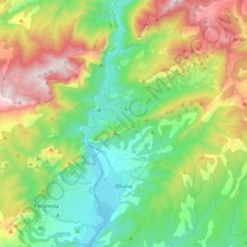
Name: Oliana topographic map, elevation, terrain.
Location: Oliana, Alt Urgell, Lleida, Catalonia, Spain (42.03935 1.29265 42.15163 1.36590)
Average elevation: 2,749 ft
Minimum elevation: 1,391 ft
Maximum elevation: 5,230 ft
Thank you for supporting this site ❤️
Make a donation
Make a donation
Gear up for your next adventure:
As an Amazon Associate, this site earns from qualifying purchases at no extra cost to you.