Geolocate

Parc Victoria topographic map

Click on the map to display elevation.

About this map

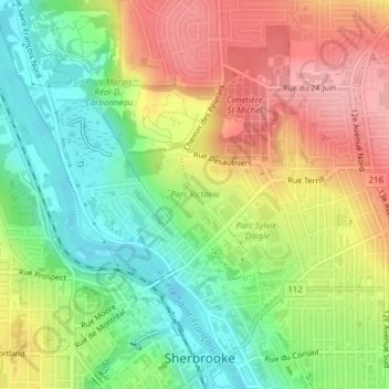
Name: Parc Victoria topographic map, elevation, terrain.

Location: Parc Victoria, Fleurimont, Sherbrooke, Estrie, Québec, Canada (45.41177 -71.89512 45.41736 -71.88440)

Average elevation: 643 ft

Minimum elevation: 449 ft

Maximum elevation: 863 ft

Other topographic maps

Click on a map to view its topography, its elevation and its terrain.

Parc Victoria

Canada > Québec > Sherbrooke

Average elevation: 643 ft

Mont Bellevue

Canada > Québec > Sherbrooke

Average elevation: 869 ft

Lac Magog

Canada > Québec > Sherbrooke

Average elevation: 686 ft

Petit-Lac-Magog

Canada > Québec > Sherbrooke

Average elevation: 679 ft

Sherbrooke

Canada > Québec > Sherbrooke

Le territoire sherbrookois est situé dans une région vallonnée, faisant partie de la chaîne des Appalaches. Ce territoire accidenté est mouillé par quatre rivières, soit la Saint-François, la Magog, la Massawippi, la rivière aux Saumons, ainsi que par une importante étendue d’eau; le lac Magog. La…

Average elevation: 817 ft

Huntingville

Canada > Québec > Sherbrooke

Average elevation: 581 ft

Gear up for your next adventure:

🌡️Portable Weather Meter - Track weather conditions on the trail
🛶Inflatable Kayak - Portable kayak for rivers, lakes, and expeditions
🛌Ultralight Sleeping Bags - Compact down bags for cold nights in the wilderness
🏔️Mountain Trail Maps - High‑detail maps for popular peaks
👖Convertible Hiking Pants - Versatile zip-off pants for changing altitudes and temperatures

As an Amazon Associate, this site earns from qualifying purchases at no extra cost to you.