
Make a donation
Gear up for your next adventure:
As an Amazon Associate, this site earns from qualifying purchases at no extra cost to you.
Jinjiang District topographic map
Click on the map to display elevation.
Make a donation
Gear up for your next adventure:
As an Amazon Associate, this site earns from qualifying purchases at no extra cost to you.
About this map
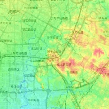
Name: Jinjiang District topographic map, elevation, terrain.
Location: Jinjiang District, Chengdu, Sichuan, China (30.54939 104.05766 30.67248 104.16825)
Average elevation: 1,634 ft
Minimum elevation: 1,552 ft
Maximum elevation: 1,781 ft
Make a donation
Gear up for your next adventure:
As an Amazon Associate, this site earns from qualifying purchases at no extra cost to you.
Other topographic maps
Click on a map to view its topography, its elevation and its terrain.
Qingcheng Mountain
"Located at the peak of Mount Qingcheng with an altitude over 1,500 m, Shangqing Palace marks the end of the touring route of Mount Qingcheng. Buildings such as Laojun Hall, Sanqing Hall, Wenwu Hall, and Tao Te Ching Preaching Hall in the Taoist temple of Shangqing Palace with several cultural relics, were…
Average elevation: 3,189 ft