
Thank you for supporting this site ❤️
Make a donation
Make a donation
Gear up for your next adventure:
As an Amazon Associate, this site earns from qualifying purchases at no extra cost to you.
Miltenberg topographic map
Click on the map to display elevation.
Thank you for supporting this site ❤️
Make a donation
Make a donation
Gear up for your next adventure:
As an Amazon Associate, this site earns from qualifying purchases at no extra cost to you.
About this map
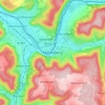
Name: Miltenberg topographic map, elevation, terrain.
Location: Miltenberg, Landkreis Miltenberg, Bavaria, 63897, Germany (49.66176 9.21597 49.74176 9.29597)
Average elevation: 915 ft
Minimum elevation: 381 ft
Maximum elevation: 1,594 ft
Thank you for supporting this site ❤️
Make a donation
Make a donation
Gear up for your next adventure:
As an Amazon Associate, this site earns from qualifying purchases at no extra cost to you.