
Make a donation
Gear up for your next adventure:
As an Amazon Associate, this site earns from qualifying purchases at no extra cost to you.
Kenadsa topographic map
Click on the map to display elevation.
Make a donation
Gear up for your next adventure:
As an Amazon Associate, this site earns from qualifying purchases at no extra cost to you.
Kenadsa
Kénadsa lies at an elevation of 784 metres (2,572 ft) on the flat rocky hamada west of Béchar. The wadi Oued Meswar is located about 6 kilometres (3.7 mi) west of the town, and meets the Oued Guir near Abadla at the locality of Ksi Ksou.
Make a donation
Gear up for your next adventure:
As an Amazon Associate, this site earns from qualifying purchases at no extra cost to you.
About this map
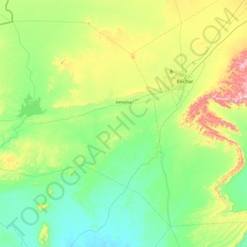
Name: Kenadsa topographic map, elevation, terrain.
Location: Kenadsa, Kénadsa District, Bechar, 08011, Algeria (31.18327 -3.13225 31.79656 -2.26963)
Average elevation: 2,451 ft
Minimum elevation: 1,867 ft
Maximum elevation: 4,327 ft
Make a donation
Gear up for your next adventure:
As an Amazon Associate, this site earns from qualifying purchases at no extra cost to you.