
Alloa topographic map
Click on the map to display elevation.
About this map
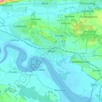
Name: Alloa topographic map, elevation, terrain.
Location: Alloa, Clackmannanshire, Scotland, FK10 1JD, United Kingdom (56.07561 -3.83224 56.15561 -3.75224)
Average elevation: 72 ft
Minimum elevation: -10 ft
Maximum elevation: 696 ft
Other topographic maps
Click on a map to view its topography, its elevation and its terrain.
River Devon
United Kingdom > Scotland > Clackmannanshire > Tillicoultry
The source of the river is Blairdenon Hill in the Ochils at an altitude of 1,800 feet (550 m). Upper areas have been dammed, creating Upper Glendevon, Lower Glendevon and Castlehill reservoirs. The Devon then flows east and southeast through Glendevon, turning southwest at Crook of Devon and then continuing…
Average elevation: 315 ft