Geolocate

Hanover topographic map

Click on the map to display elevation.

About this map

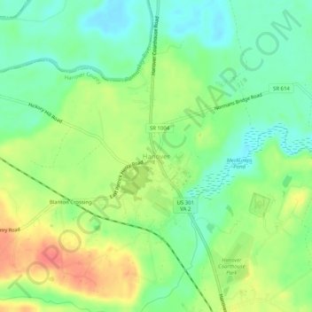
Name: Hanover topographic map, elevation, terrain.

Location: Hanover, Hanover County, Virginia, 23069, United States (37.74653 -77.39026 37.78653 -77.35026)

Average elevation: 92 ft

Minimum elevation: 13 ft

Maximum elevation: 203 ft

Hanover County trails, hiking, mountain biking, running and outdoor activities

Other topographic maps

Click on a map to view its topography, its elevation and its terrain.

Hanover

United States > Virginia > Hanover County > Hanover

Average elevation: 95 ft

Gear up for your next adventure:

🥾Men's Hiking Boots - Durable, waterproof footwear for rugged terrain and steep inclines
🖼️Topo Map Wall Art - Decorative topographic prints of famous peaks and regions
Backpacking Tent - Lightweight and durable tent for multi‑day hikes
🏕️Family Camping Gear - Essentials for group camping trips
🔋Rechargeable Batteries - Power up your outdoor devices

As an Amazon Associate, this site earns from qualifying purchases at no extra cost to you.