
Gangotri Glacier topographic map
Interactive map
Click on the map to display elevation.
About this map
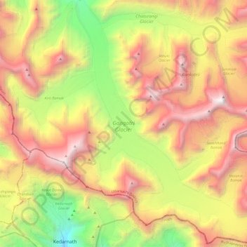
Name: Gangotri Glacier topographic map, elevation, terrain.
Location: Gangotri Glacier, Bhatwari, Uttarkashi, Uttarakhand, India (30.73027 79.07689 30.92663 79.27806)
Average elevation: 17,254 ft
Minimum elevation: 11,581 ft
Maximum elevation: 23,031 ft
Other topographic maps
Click on a map to view its topography, its elevation and its terrain.
Uttarkashi
India > Uttarakhand > Bhatwari
Uttarkashi, Bhatwari, Uttarkashi District, Uttarakhand, 249193, India
Average elevation: 5,312 ft
Harsil
India > Uttarakhand > Bhatwari
Harsil, Bhatwari, Uttarkashi district, Uttarakhand, India
Average elevation: 9,058 ft
Dharali
India > Uttarakhand > Bhatwari > Dharali
Dharali, Bhatwari, Uttarkashi district, Uttarakhand, India
Average elevation: 9,721 ft
Shilla
India > Uttarakhand > Bhatwari
Shilla, Bhatwari, Uttarkashi district, Uttarakhand, India
Average elevation: 7,146 ft