
Harsil topographic map
Interactive map
Click on the map to display elevation.
About this map
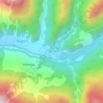
Name: Harsil topographic map, elevation, terrain.
Location: Harsil, Bhatwari, Uttarkashi district, Uttarakhand, India (31.03390 78.74709 31.03965 78.75525)
Average elevation: 9,058 ft
Minimum elevation: 8,084 ft
Maximum elevation: 10,991 ft
Other topographic maps
Click on a map to view its topography, its elevation and its terrain.
Uttarkashi
India > Uttarakhand > Bhatwari
Uttarkashi, Bhatwari, Uttarkashi District, Uttarakhand, 249193, India
Average elevation: 5,312 ft
Gangotri Glacier
India > Uttarakhand > Bhatwari
Gangotri Glacier, Bhatwari, Uttarkashi, Uttarakhand, India
Average elevation: 17,254 ft
Dharali
India > Uttarakhand > Bhatwari > Dharali
Dharali, Bhatwari, Uttarkashi district, Uttarakhand, India
Average elevation: 9,721 ft
Shilla
India > Uttarakhand > Bhatwari
Shilla, Bhatwari, Uttarkashi district, Uttarakhand, India
Average elevation: 7,146 ft