
Make a donation
Gear up for your next adventure:
As an Amazon Associate, this site earns from qualifying purchases at no extra cost to you.
Raeren topographic map
Click on the map to display elevation.
Make a donation
Gear up for your next adventure:
As an Amazon Associate, this site earns from qualifying purchases at no extra cost to you.
Raeren
Raeren ligt aan de rand van het Hertogenwald, op een hoogte van ongeveer 300 meter. In het noorden liggen enkele kleinere boscomplexen. De Iterbach stroomt door Raeren in noordoostelijke richting. In het zuiden van Raeren stroomt de Vesder. Op het grondgebied van de deelgemeente Eynatten ontspringt de Geul.
Make a donation
Gear up for your next adventure:
As an Amazon Associate, this site earns from qualifying purchases at no extra cost to you.
About this map
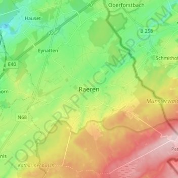
Name: Raeren topographic map, elevation, terrain.
Location: Raeren, Verviers, Luik, Wallonië, 4730, België (50.63613 6.07084 50.71613 6.15084)
Average elevation: 1,024 ft
Minimum elevation: 702 ft
Maximum elevation: 1,496 ft
Make a donation
Gear up for your next adventure:
As an Amazon Associate, this site earns from qualifying purchases at no extra cost to you.
Other topographic maps
Click on a map to view its topography, its elevation and its terrain.
Hauset
België > Luik > Verviers > Raeren
Hauset ligt in het dal van de Geul op een hoogte van ongeveer 250 meter. De plaats wordt omringd door bossen, in het noorden vindt men uitlopers van het Aachener Wald. De Rotsiefbach stroomt vanuit een hoogte in dit bos zuidwaarts naar de Geul.
Average elevation: 876 ft