Geolocate

Halifax topographic map

Click on the map to display elevation.

About this map

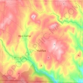
Name: Halifax topographic map, elevation, terrain.

Location: Halifax, Windham County, Vermont, 05358, United States (42.73325 -72.80697 42.82914 -72.68063)

Average elevation: 1,453 ft

Minimum elevation: 735 ft

Maximum elevation: 1,991 ft

Windham County trails, hiking, mountain biking, running and outdoor activities

Other topographic maps

Click on a map to view its topography, its elevation and its terrain.

Ames Hill

United States > Vermont > Windham County > Marlboro

Average elevation: 1,572 ft

Guilford

United States > Vermont > Windham County > Guilford

Average elevation: 607 ft

College Hill

United States > Vermont > Windham County > Jamaica

Average elevation: 1,578 ft

South Wardsboro

United States > Vermont > Windham County > Wardsboro

Average elevation: 1,768 ft

Hogback Mountain

United States > Vermont > Windham County > Marlboro

Average elevation: 2,014 ft

West Wardsboro

United States > Vermont > Windham County > Wardsboro

Average elevation: 1,696 ft

West Halifax

United States > Vermont > Windham County > Halifax

Average elevation: 1,460 ft

Stowe Mountain

United States > Vermont > Windham County > Halifax

Average elevation: 1,302 ft

Gear up for your next adventure:

🕶️GPS Smartphone Mount - Secure mount for phone navigation
👟Trail Running Shoes - Lightweight shoes for trail runners
🗃️Trail First Aid Kit - Essential kit for outdoor injuries and emergencies
🧴Hand Sanitizer - Keep hands clean while hiking
🧭Orienteering Set - Complete compass and map reading kit

As an Amazon Associate, this site earns from qualifying purchases at no extra cost to you.