
Make a donation
Gear up for your next adventure:
As an Amazon Associate, this site earns from qualifying purchases at no extra cost to you.
Watertown topographic map
Click on the map to display elevation.
Make a donation
Gear up for your next adventure:
As an Amazon Associate, this site earns from qualifying purchases at no extra cost to you.
Watertown
Watertown is around 60 miles (97 kilometers) northwest of Syracuse, 20 miles (32 kilometers) south of the Thousand Islands and 328 miles (530 kilometers) northwest of New York City. According to the United States Census Bureau, the city has a total area of 9.3 square miles (24 km2), of which 9.0 square miles (23 km2) are land and 0.3 square miles (0.78 km2) (3.45 percent) is water. Before the area was settled, all the land was rough and forested. Elevation was also a problem. The Black River, flowing westward through the city toward Lake Ontario, is a world-renowned kayaking destination. Competition-level kayaking events, such as the Blackwater Challenge, have been held on the river.
Make a donation
Gear up for your next adventure:
As an Amazon Associate, this site earns from qualifying purchases at no extra cost to you.
About this map
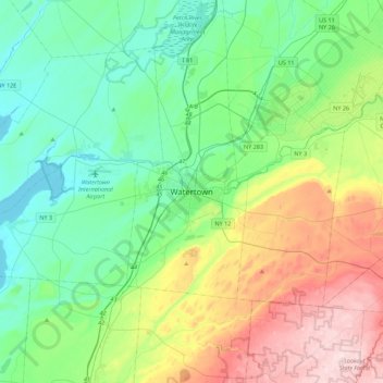
Name: Watertown topographic map, elevation, terrain.
Average elevation: 643 ft
Minimum elevation: 236 ft
Maximum elevation: 1,624 ft
Jefferson County trails, hiking, mountain biking, running and outdoor activities
Make a donation
Gear up for your next adventure:
As an Amazon Associate, this site earns from qualifying purchases at no extra cost to you.
Other topographic maps
Click on a map to view its topography, its elevation and its terrain.
Just Room Enough Island
United States > New York > Jefferson County > Village of Alexandria Bay
Average elevation: 256 ft
Hub Island
United States > New York > Jefferson County > Town of Clayton > Grenell
Average elevation: 256 ft
Make a donation
Gear up for your next adventure:
As an Amazon Associate, this site earns from qualifying purchases at no extra cost to you.
Friendly Island
United States > New York > Jefferson County > Village of Alexandria Bay
Average elevation: 259 ft
Village of Antwerp
United States > New York > Jefferson County > Town of Antwerp
Average elevation: 525 ft
Make a donation
Gear up for your next adventure:
As an Amazon Associate, this site earns from qualifying purchases at no extra cost to you.
Village of Dexter
United States > New York > Jefferson County > Town of Brownville
Average elevation: 315 ft
Murray Isle
United States > New York > Jefferson County > Town of Clayton > Grenell
Average elevation: 256 ft
Make a donation
Gear up for your next adventure:
As an Amazon Associate, this site earns from qualifying purchases at no extra cost to you.
Butterfield Lake
United States > New York > Jefferson County > Town of Theresa > Redwood
Average elevation: 325 ft
Village of Cape Vincent
United States > New York > Jefferson County > Town of Cape Vincent
Average elevation: 276 ft
Make a donation
Gear up for your next adventure:
As an Amazon Associate, this site earns from qualifying purchases at no extra cost to you.
Village of Theresa
United States > New York > Jefferson County > Town of Theresa
Average elevation: 397 ft
Village of Brownville
United States > New York > Jefferson County > Town of Brownville
Average elevation: 361 ft
Make a donation
Gear up for your next adventure:
As an Amazon Associate, this site earns from qualifying purchases at no extra cost to you.