Geolocate

Khalapur topographic map

Click on the map to display elevation.

About this map

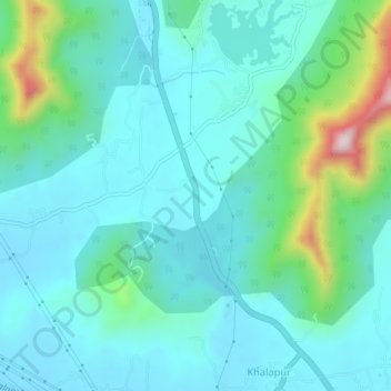
Name: Khalapur topographic map, elevation, terrain.

Location: Khalapur, Khalapur Taluka, Raigad, Maharashtra, 410202, India (18.81217 73.26525 18.85217 73.30525)

Average elevation: 266 ft

Minimum elevation: 125 ft

Maximum elevation: 1,145 ft

Other topographic maps

Click on a map to view its topography, its elevation and its terrain.

Patalganga

India > Maharashtra > Khalapur Taluka > Jambrung

Average elevation: 312 ft

Morbe Dam

India > Maharashtra > Khalapur Taluka > Chowk

Average elevation: 200 ft

Gear up for your next adventure:

🛡️Bear Spray Outdoor - Protection in bear country hikes
🧷Carabiner Set - Durable clips for gear attachment
🔭Compact Binoculars - HD vision for scouting terrain and identifying distant landmarks
🔌Solar Panel Charger - Charge gear sustainably outdoors
🏕️Tent Footprint - Protect your tent base from wear

As an Amazon Associate, this site earns from qualifying purchases at no extra cost to you.