
恩施市 topographic map
Interactive map
Click on the map to display elevation.
About this map
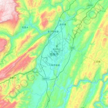
Name: 恩施市 topographic map, elevation, terrain.
Location: 恩施市, 恩施土家族苗族自治州, 湖北省, 445000, 中国 (30.13749 109.31464 30.45749 109.63464)
Average elevation: 2,674 ft
Minimum elevation: 1,188 ft
Maximum elevation: 6,257 ft
恩施市位于清江上游;境内大部分为山地,平均海拔在900米以上。
Other topographic maps
Click on a map to view its topography, its elevation and its terrain.