
Make a donation
Gear up for your next adventure:
As an Amazon Associate, this site earns from qualifying purchases at no extra cost to you.
Greenbrier Cove topographic map
Click on the map to display elevation.
Make a donation
Gear up for your next adventure:
As an Amazon Associate, this site earns from qualifying purchases at no extra cost to you.
About this map
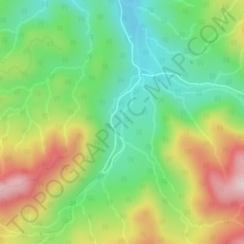
Name: Greenbrier Cove topographic map, elevation, terrain.
Location: Greenbrier Cove, Sevier County, Tennessee, United States (35.69816 -83.38506 35.70667 -83.38332)
Average elevation: 2,116 ft
Minimum elevation: 1,617 ft
Maximum elevation: 2,867 ft
Make a donation
Gear up for your next adventure:
As an Amazon Associate, this site earns from qualifying purchases at no extra cost to you.
Other topographic maps
Click on a map to view its topography, its elevation and its terrain.
Gatlinburg
United States > Tennessee > Sevier County
Gatlinburg is nestled within the Appalachian Mountains, specifically at the junction of the Ridge-and-Valley and the Blue Ridge provinces, making its topography notably rugged and varied. The town itself sits at an elevation of approximately 1,500 feet above sea level, surrounded by steep ridges and deep…
Average elevation: 1,893 ft
Great Smoky Mountains National Park
United States > Tennessee > Sevier County
Elevations in the park range from about 875 feet (267 m) to 6,643 feet (2,025 m) at the summit of Clingmans Dome. Within the park a total of sixteen mountains reach higher than 5,000 feet (1,520 m).
Average elevation: 2,510 ft
Make a donation
Gear up for your next adventure:
As an Amazon Associate, this site earns from qualifying purchases at no extra cost to you.
Great Smoky Mountains National Park
United States > Tennessee > Sevier County
Elevations in the park range from about 875 feet (267 m) to 6,643 feet (2,025 m) at the summit of Clingmans Dome. Within the park a total of sixteen mountains reach higher than 5,000 feet (1,520 m).
Average elevation: 2,510 ft
Mount Le Conte
United States > Tennessee > Sevier County
Mount Le Conte (or LeConte) is a mountain located within the Great Smoky Mountains National Park in Sevier County, Tennessee. At 6,593 ft (2,010 m) it is the third highest peak in the national park, behind Kuwohi (formerly Clingmans Dome) (6,643 ft (2,025 m)) and Mount Guyot (6,621 ft (2,018 m)). It is also…
Average elevation: 5,449 ft
Make a donation
Gear up for your next adventure:
As an Amazon Associate, this site earns from qualifying purchases at no extra cost to you.
Make a donation
Gear up for your next adventure:
As an Amazon Associate, this site earns from qualifying purchases at no extra cost to you.
Make a donation
Gear up for your next adventure:
As an Amazon Associate, this site earns from qualifying purchases at no extra cost to you.
Make a donation
Gear up for your next adventure:
As an Amazon Associate, this site earns from qualifying purchases at no extra cost to you.
Sugarlands
United States > Tennessee > Sevier County
In the 19the century, mountain areas became popular vacation destinations, especially since large urban areas were often wanting for clean air and scenery. Mineral-rich mountain springs were thought to have health-restoring qualities, and the cool air of the higher elevations lured people seeking relief from…
Average elevation: 1,991 ft
Make a donation
Gear up for your next adventure:
As an Amazon Associate, this site earns from qualifying purchases at no extra cost to you.
Make a donation
Gear up for your next adventure:
As an Amazon Associate, this site earns from qualifying purchases at no extra cost to you.
Make a donation
Gear up for your next adventure:
As an Amazon Associate, this site earns from qualifying purchases at no extra cost to you.
Conner Heights
United States > Tennessee > Sevier County > Pigeon Forge > Conner Heights
Average elevation: 1,220 ft
Make a donation
Gear up for your next adventure:
As an Amazon Associate, this site earns from qualifying purchases at no extra cost to you.