
Make a donation
Gear up for your next adventure:
As an Amazon Associate, this site earns from qualifying purchases at no extra cost to you.
Table Mountain topographic map
Click on the map to display elevation.
Make a donation
Gear up for your next adventure:
As an Amazon Associate, this site earns from qualifying purchases at no extra cost to you.
About this map
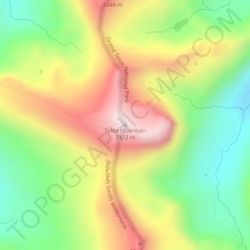
Name: Table Mountain topographic map, elevation, terrain.
Average elevation: 9,800 ft
Minimum elevation: 8,747 ft
Maximum elevation: 11,063 ft
Make a donation
Gear up for your next adventure:
As an Amazon Associate, this site earns from qualifying purchases at no extra cost to you.
Other topographic maps
Click on a map to view its topography, its elevation and its terrain.
Jackson
États-Unis d'Amérique > Wyoming > Teton County
C'est une station de ski située à 1 901 m d’altitude. Elle possède en tout trois domaines skiables. L'été, elle permet de pratiquer des activités de plein air comme l'équitation, la pêche, le rafting ou encore la randonnée.
Average elevation: 6,703 ft