
Make a donation
Gear up for your next adventure:
As an Amazon Associate, this site earns from qualifying purchases at no extra cost to you.
Tlalpan topographic map
Click on the map to display elevation.
Make a donation
Gear up for your next adventure:
As an Amazon Associate, this site earns from qualifying purchases at no extra cost to you.
Tlalpan
Much of the geology of the area formed when the Xitle volcano erupted in 100 CE, which created numerous caves and formed the basis of the volcanic soil that, 600 years later, makes the area's agriculture so productive. The borough has two types of soil: rocky in higher elevations and—in lower areas—less solid and containing more groundwater, making it somewhat spongy. The area experiences regular seismic activity, mostly of low intensity, which is believed mostly from small ancient faults reactivated by regional stresses, or by the sinking of the Valley of Mexico. The south of the Valley, including Tlalpan, is also affected by the underground movement of magma, especially when such contacts the waterlogged regions of the former Lake Xochimilco. Most of these tremors go unnoticed except for those that occur close to the surface such as the one centered 5 km south of the Ciudad Universitaria on 16 October 2005 (mag. 3.1). However, even this one was not felt far from its epicenter. Three areas in the borough are susceptible to seismic activity over 7.5 on the Richter scale: Colonia Isidro Fabela, Villa Coapa, and Tlalpan Centro. These areas are subject to special building inspections and annual earthquake drills. The borough has a warmer and more humid climate than the rest of Mexico City.
Make a donation
Gear up for your next adventure:
As an Amazon Associate, this site earns from qualifying purchases at no extra cost to you.
About this map
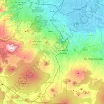
Name: Tlalpan topographic map, elevation, terrain.
Location: Tlalpan, Mexico City, Mexico (19.08938 -99.31625 19.31226 -99.10093)
Average elevation: 9,295 ft
Minimum elevation: 7,316 ft
Maximum elevation: 12,897 ft
Make a donation
Gear up for your next adventure:
As an Amazon Associate, this site earns from qualifying purchases at no extra cost to you.
Other topographic maps
Click on a map to view its topography, its elevation and its terrain.
Mexico City
Mexico > Mexico City > Mexico City
Mexico City is located in the Valley of Mexico, sometimes called the Basin of Mexico. This valley is located in the Trans-Mexican Volcanic Belt in the high plateaus of south-central Mexico. It has a minimum altitude of 2,200 meters (7,200 feet) above sea level and is surrounded by mountains and volcanoes that…
Average elevation: 7,615 ft
Make a donation
Gear up for your next adventure:
As an Amazon Associate, this site earns from qualifying purchases at no extra cost to you.
Make a donation
Gear up for your next adventure:
As an Amazon Associate, this site earns from qualifying purchases at no extra cost to you.