
Make a donation
Gear up for your next adventure:
As an Amazon Associate, this site earns from qualifying purchases at no extra cost to you.
Monarch Butterfly Biosphere Reserve topographic map
Click on the map to display elevation.
Make a donation
Gear up for your next adventure:
As an Amazon Associate, this site earns from qualifying purchases at no extra cost to you.
Monarch Butterfly Biosphere Reserve
The reserve extends from the mountainous forests of eastern Michoacán to western Mexico State 100 km northwest of Mexico City. The reserve in Michoacán contains the highest elevations in the state, including peaks that reach 2,700 masl (metres above sea level). The climate is classified as being temperate and somewhat moist with a rainy season in the summer. The average maximum temperature is 22 °C (71 °F). Sub-climates exist in this area: cool and semi moist, semi cold and semi moist, and cold and semi moist.
Make a donation
Gear up for your next adventure:
As an Amazon Associate, this site earns from qualifying purchases at no extra cost to you.
About this map
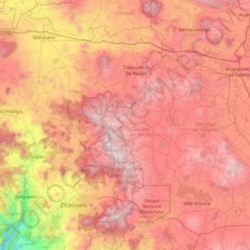
Name: Monarch Butterfly Biosphere Reserve topographic map, elevation, terrain.
Average elevation: 8,074 ft
Minimum elevation: 2,966 ft
Maximum elevation: 11,873 ft
Make a donation
Gear up for your next adventure:
As an Amazon Associate, this site earns from qualifying purchases at no extra cost to you.