
Thank you for supporting this site ❤️
Make a donation
Make a donation
Gear up for your next adventure:
As an Amazon Associate, this site earns from qualifying purchases at no extra cost to you.
Chulumal topographic map
Click on the map to display elevation.
Thank you for supporting this site ❤️
Make a donation
Make a donation
Gear up for your next adventure:
As an Amazon Associate, this site earns from qualifying purchases at no extra cost to you.
About this map
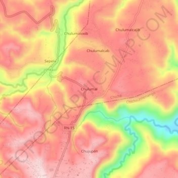
Name: Chulumal topographic map, elevation, terrain.
Location: Chulumal, Chiché, Quiché, GUATEMALA, Guatemala (14.94748 -91.12131 14.98748 -91.08131)
Average elevation: 6,467 ft
Minimum elevation: 5,728 ft
Maximum elevation: 6,808 ft
Thank you for supporting this site ❤️
Make a donation
Make a donation
Gear up for your next adventure:
As an Amazon Associate, this site earns from qualifying purchases at no extra cost to you.