Geolocate

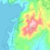
Miñarzo topographic map

Click on the map to display elevation.

About this map

Name: Miñarzo topographic map, elevation, terrain.

Location: Miñarzo, Lira, Carnota, Muros, La Coruña, Galicia, 15292, España (42.77737 -9.15165 42.81737 -9.11165)

Average elevation: 144 ft

Minimum elevation: -3 ft

Maximum elevation: 1,004 ft

Other topographic maps

Click on a map to view its topography, its elevation and its terrain.
O Pindo

España > Galicia > Muros > Carnota

Average elevation: 367 ft

Gear up for your next adventure:

⛺Backpacking Tent - Lightweight and durable tent for multi‑day hikes
🥘Titanium Cookware - Durable, featherlight pots and pans for backpacking
🌡️Portable Weather Meter - Track weather conditions on the trail
🔭Telescopic Hiking Pole - Adjustable pole for hiking stability
🪶Multi‑Purpose Knife - Useful blade for camp and trail

As an Amazon Associate, this site earns from qualifying purchases at no extra cost to you.