Geolocate

Birkfeld topographic map

Click on the map to display elevation.

About this map

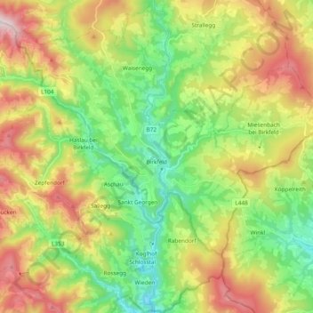
Name: Birkfeld topographic map, elevation, terrain.

Location: Birkfeld, Bezirk Weiz, Styria, 8190, Austria (47.29436 15.58581 47.42177 15.74950)

Average elevation: 2,828 ft

Minimum elevation: 1,621 ft

Maximum elevation: 4,685 ft

Gear up for your next adventure:

🛌Ultralight Sleeping Bags - Compact down bags for cold nights in the wilderness
🧦Hiking Socks - Comfortable socks to prevent blisters on long hikes
🌡️Portable Weather Meter - Track weather conditions on the trail
🚑Emergency Bivvies - Heat-reflective sleeping bags for survival situations
📶Vehicle Signal Boosters - Improve reception in rural areas while driving to trailheads

As an Amazon Associate, this site earns from qualifying purchases at no extra cost to you.