Geolocate

Monticello topographic map

Click on the map to display elevation.

About this map

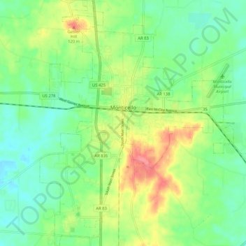
Name: Monticello topographic map, elevation, terrain.

Location: Monticello, Drew County, Arkansas, United States (33.58082 -91.82644 33.66705 -91.73608)

Average elevation: 256 ft

Minimum elevation: 167 ft

Maximum elevation: 410 ft

Drew County trails, hiking, mountain biking, running and outdoor activities

Gear up for your next adventure:

🪶Thermal Camp Blanket - Extra warmth for cold nights
Backpacking Tents - Weight-optimized shelters for multi-day topographic surveys
🧭Orienteering Set - Complete compass and map reading kit
❄️Traction Cleats - Prevent slips on icy trails during winter hikes
🧦Merino Wool Socks - Moisture-wicking, blister-preventing socks for long treks

As an Amazon Associate, this site earns from qualifying purchases at no extra cost to you.