Geolocate

Aralam topographic map

Click on the map to display elevation.

About this map

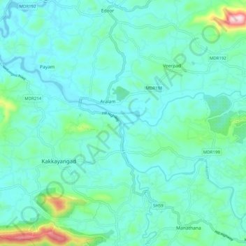
Name: Aralam topographic map, elevation, terrain.

Location: Aralam, Iritty, Kannur district, Kerala, 670703, India (11.91416 75.68021 11.99043 75.78028)

Average elevation: 282 ft

Minimum elevation: 69 ft

Maximum elevation: 1,407 ft

Gear up for your next adventure:

🌄Hiking Binoculars - Compact binoculars for scenic views and trail spotting
🌡️Portable Weather Meter - Track weather conditions on the trail
🧯Portable Fire Pit - Compact fire pit for camping spots
🔥Fast-Boil Camping Stoves - Efficient cooking systems for quick trail meals
🧦Hiking Socks - Comfortable socks to prevent blisters on long hikes

As an Amazon Associate, this site earns from qualifying purchases at no extra cost to you.