
Thank you for supporting this site ❤️
Make a donation
Make a donation
Gear up for your next adventure:
As an Amazon Associate, this site earns from qualifying purchases at no extra cost to you.
Lanaja topographic map
Click on the map to display elevation.
Thank you for supporting this site ❤️
Make a donation
Make a donation
Gear up for your next adventure:
As an Amazon Associate, this site earns from qualifying purchases at no extra cost to you.
About this map
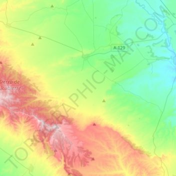
Name: Lanaja topographic map, elevation, terrain.
Location: Lanaja, Los Monegros, Huesca, Aragon, Spain (41.63014 -0.46065 41.83717 -0.24632)
Average elevation: 1,430 ft
Minimum elevation: 810 ft
Maximum elevation: 2,582 ft
Thank you for supporting this site ❤️
Make a donation
Make a donation
Gear up for your next adventure:
As an Amazon Associate, this site earns from qualifying purchases at no extra cost to you.