
Eastern Tigray topographic map
Interactive map
Click on the map to display elevation.
About this map
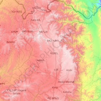
Name: Eastern Tigray topographic map, elevation, terrain.
Location: Eastern Tigray, Tigray, Äthiopien (13.55383 39.18949 14.60902 39.99379)
Average elevation: 5,968 ft
Minimum elevation: -56 ft
Maximum elevation: 10,797 ft
Other topographic maps
Click on a map to view its topography, its elevation and its terrain.
Haddush Addi
Äthiopien > Tigray > May Ch'iwara > Haddush Addi
Haddush Addi, May Ch'iwara, Central Tigray, Tigray, Äthiopien
Average elevation: 8,507 ft
Beati Akor
Äthiopien > Tigray > Beati Akor
Beati Akor, Eastern Tigray, Tigray, 251, Äthiopien
Average elevation: 6,919 ft