Geolocate

Tarma topographic map

Click on the map to display elevation.

About this map

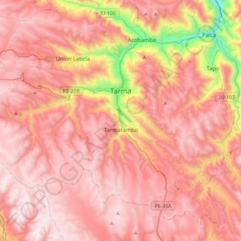
Name: Tarma topographic map, elevation, terrain.

Location: Tarma, Province of Tarma, Junín, 12651, Peru (-11.56713 -75.91706 -11.35127 -75.59396)

Average elevation: 12,835 ft

Minimum elevation: 8,780 ft

Maximum elevation: 14,934 ft

Other topographic maps

Click on a map to view its topography, its elevation and its terrain.

Cañete

Peru > Junín > Mazamari

Average elevation: 2,418 ft

Gear up for your next adventure:

📡Handheld GPS Device - Reliable handheld GPS for outdoor navigation
🛰️Handheld GPS Units - Professional satellite navigators for precise backcountry mapping
📌Outdoor GPS Map App - Apps and devices for digital topographic navigation
🏫Relief Map Kits - Hands-on tools for teaching landforms and elevation
🎒Hydration Pack - Hands‑free water reservoir for long hikes

As an Amazon Associate, this site earns from qualifying purchases at no extra cost to you.