
Make a donation
Gear up for your next adventure:
As an Amazon Associate, this site earns from qualifying purchases at no extra cost to you.
Capão da Canoa topographic map
Click on the map to display elevation.
Make a donation
Gear up for your next adventure:
As an Amazon Associate, this site earns from qualifying purchases at no extra cost to you.
Capão da Canoa
Localiza-se na latitude 29º44'44" sul e na longitude 50º00'35" oeste, elevando-se à altitude de 4,80 m acima do nível do mar (MANM). Segundo estimativas do IBGE, o município de Capão da Canoa conta com a maior população do litoral norte gaúcho.
Make a donation
Gear up for your next adventure:
As an Amazon Associate, this site earns from qualifying purchases at no extra cost to you.
About this map
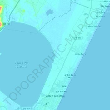
Name: Capão da Canoa topographic map, elevation, terrain.
Average elevation: 13 ft
Minimum elevation: -3 ft
Maximum elevation: 554 ft
Make a donation
Gear up for your next adventure:
As an Amazon Associate, this site earns from qualifying purchases at no extra cost to you.
Other topographic maps
Click on a map to view its topography, its elevation and its terrain.
Bananeiras
Brasil > Rio Grande do Sul > Aglomeração Urbana do Litoral Norte > Itati
Average elevation: 1,070 ft
Praça Pedro Cardoso Duarte
Brasil > Rio Grande do Sul > Aglomeração Urbana do Litoral Norte > Torres
Average elevation: 16 ft
Praia Nova Tramandai Sul
Brasil > Rio Grande do Sul > Aglomeração Urbana do Litoral Norte > Tramandaí
Average elevation: 13 ft
Morro das Furnas
Brasil > Rio Grande do Sul > Aglomeração Urbana do Litoral Norte > Torres
Average elevation: 13 ft
Make a donation
Gear up for your next adventure:
As an Amazon Associate, this site earns from qualifying purchases at no extra cost to you.
Praia Real
Brasil > Rio Grande do Sul > Aglomeração Urbana do Litoral Norte > Torres
Average elevation: 16 ft
Praia Paraíso
Brasil > Rio Grande do Sul > Aglomeração Urbana do Litoral Norte > Torres
Average elevation: 16 ft
Morro da Borússia
Brasil > Rio Grande do Sul > Aglomeração Urbana do Litoral Norte > Osório
Average elevation: 653 ft
Amaragi
Brasil > Rio Grande do Sul > Aglomeração Urbana do Litoral Norte > Terra de Areia
Average elevation: 16 ft
Make a donation
Gear up for your next adventure:
As an Amazon Associate, this site earns from qualifying purchases at no extra cost to you.
Alto Caraá
Brasil > Rio Grande do Sul > Aglomeração Urbana do Litoral Norte > Caraá
Average elevation: 692 ft
Lagoa da Ilhota
Brasil > Rio Grande do Sul > Aglomeração Urbana do Litoral Norte > Osório
Average elevation: 46 ft
Morro do Farol
Brasil > Rio Grande do Sul > Aglomeração Urbana do Litoral Norte > Torres
Average elevation: 13 ft
Mirante do Morro da Borússia
Brasil > Rio Grande do Sul > Aglomeração Urbana do Litoral Norte > Osório
Average elevation: 646 ft
Make a donation
Gear up for your next adventure:
As an Amazon Associate, this site earns from qualifying purchases at no extra cost to you.
Praça das Carretas
Brasil > Rio Grande do Sul > Aglomeração Urbana do Litoral Norte > Osório
Average elevation: 72 ft
Balneário Atlântico
Brasil > Rio Grande do Sul > Aglomeração Urbana do Litoral Norte > Arroio do Sal
Average elevation: 16 ft
Fernando Ferrari
Brasil > Rio Grande do Sul > Aglomeração Urbana do Litoral Norte > Três Cachoeiras
Average elevation: 223 ft
Faxinal do Morro Alto
Brasil > Rio Grande do Sul > Aglomeração Urbana do Litoral Norte > Maquiné
Average elevation: 16 ft
Make a donation
Gear up for your next adventure:
As an Amazon Associate, this site earns from qualifying purchases at no extra cost to you.
Capão Novo
Brasil > Rio Grande do Sul > Aglomeração Urbana do Litoral Norte > Capão da Canoa
Average elevation: 13 ft
Guarita
Brasil > Rio Grande do Sul > Aglomeração Urbana do Litoral Norte > Torres
Average elevation: 13 ft
Dunas Altas
Brasil > Rio Grande do Sul > Aglomeração Urbana do Litoral Norte > Palmares do Sul
Average elevation: 13 ft
Praia Santa Helena
Brasil > Rio Grande do Sul > Aglomeração Urbana do Litoral Norte > Torres
Average elevation: 16 ft
Make a donation
Gear up for your next adventure:
As an Amazon Associate, this site earns from qualifying purchases at no extra cost to you.
Magistério
Brasil > Rio Grande do Sul > Aglomeração Urbana do Litoral Norte > Balneário Pinhal
Average elevation: 13 ft
Mariápolis
Brasil > Rio Grande do Sul > Aglomeração Urbana do Litoral Norte > Osório
Average elevation: 10 ft
Praia Lagoa do Jardim
Brasil > Rio Grande do Sul > Aglomeração Urbana do Litoral Norte > Torres
Average elevation: 20 ft
Morro Azul
Brasil > Rio Grande do Sul > Aglomeração Urbana do Litoral Norte > Três Cachoeiras
Average elevation: 285 ft
Make a donation
Gear up for your next adventure:
As an Amazon Associate, this site earns from qualifying purchases at no extra cost to you.
Pixirica
Brasil > Rio Grande do Sul > Aglomeração Urbana do Litoral Norte > Morrinhos do Sul > Pixirica
Average elevation: 226 ft
Alto Rio dos Sinos
Brasil > Rio Grande do Sul > Aglomeração Urbana do Litoral Norte > Caraá
Average elevation: 604 ft