Geolocate

Hergolding topographic map

Click on the map to display elevation.

About this map

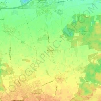
Name: Hergolding topographic map, elevation, terrain.

Location: Hergolding, Baldham Dorf, Vaterstetten, Landkreis Ebersberg, Bayern, 85599, Deutschland (48.10580 11.77041 48.14580 11.81041)

Average elevation: 1,759 ft

Minimum elevation: 1,693 ft

Maximum elevation: 1,798 ft

Other topographic maps

Click on a map to view its topography, its elevation and its terrain.

85598

Deutschland > Bayern > Landkreis Ebersberg > Vaterstetten > Baldham Dorf

Average elevation: 1,778 ft

Gear up for your next adventure:

🎒Day Hiking Backpack - Lightweight backpack perfect for day trips and outdoor adventures
🔌Solar Panel Charger - Charge gear sustainably outdoors
🏕️Tent Footprint - Protect your tent base from wear
🛠️Backpacking Tool Kit - Essential toolkit for outdoor repairs
🛡️Insect Repellent - Protection against bugs during outdoor activities

As an Amazon Associate, this site earns from qualifying purchases at no extra cost to you.