Geolocate

Pesaro topographic map

Click on the map to display elevation.

About this map

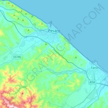
Name: Pesaro topographic map, elevation, terrain.

Location: Pesaro, Pesaro e Urbino, Marche, Italy (43.76916 12.77096 43.96547 12.96283)

Average elevation: 230 ft

Minimum elevation: -10 ft

Maximum elevation: 1,808 ft

Gear up for your next adventure:

🧭Compass with Lanyard - Easy‑carry compass for navigation
🦟Ultrasonic Repellers - Create a bug-free zone at your camp or rest stop
🩳Quick‑Dry Hiking Shorts - Comfortable and quick‑dry shorts for summer hiking
🌐World Map Poster - Decorative world maps with topographic info
❄️Traction Cleats - Prevent slips on icy trails during winter hikes

As an Amazon Associate, this site earns from qualifying purchases at no extra cost to you.