
Make a donation
Gear up for your next adventure:
As an Amazon Associate, this site earns from qualifying purchases at no extra cost to you.
Nederbrakel topographic map
Click on the map to display elevation.
Make a donation
Gear up for your next adventure:
As an Amazon Associate, this site earns from qualifying purchases at no extra cost to you.
Nederbrakel
Nederbrakel ligt in de Vlaamse Ardennen en de hoogte varieer van 38 tot omstreeks 103 meter. De Zwalm. De bodem is lemig en er zijn bronnen. Natuurgebieden zijn het Hayesbos, dat in Henegouwen aansluit op het Livierenbos waar ook de Verrebeek ontspringt. Verder is er het natuur- en recreatiegebied De Rijdtmeersen.
Make a donation
Gear up for your next adventure:
As an Amazon Associate, this site earns from qualifying purchases at no extra cost to you.
About this map
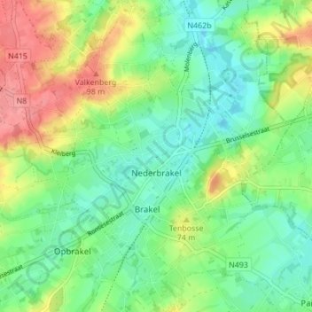
Name: Nederbrakel topographic map, elevation, terrain.
Average elevation: 187 ft
Minimum elevation: 92 ft
Maximum elevation: 348 ft
Make a donation
Gear up for your next adventure:
As an Amazon Associate, this site earns from qualifying purchases at no extra cost to you.
Other topographic maps
Click on a map to view its topography, its elevation and its terrain.
Make a donation
Gear up for your next adventure:
As an Amazon Associate, this site earns from qualifying purchases at no extra cost to you.