Geolocate

Payao topographic map

Click on the map to display elevation.

About this map
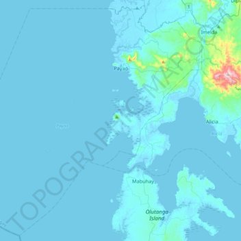
Name: Payao topographic map, elevation, terrain.

Location: Payao, Zamboanga Sibugay, Zamboanga Peninsula, 7008, Philippines (7.33514 122.55866 7.68175 122.92453)

Average elevation: 66 ft

Minimum elevation: -13 ft

Maximum elevation: 1,880 ft

Other topographic maps

Click on a map to view its topography, its elevation and its terrain.

San Isidro

Philippines > Zamboanga Sibugay > Payao

Average elevation: 358 ft

Kulisap

Philippines > Zamboanga Sibugay > Payao

Average elevation: 187 ft

Gear up for your next adventure:

🔊Portable Camp Speaker - Music and alerts at camp
📷Action Cameras - Rugged cameras to document your journeys across rugged terrain
🕶️Glacier Sunglasses - Side shields to protect eyes from high-altitude snow glare
🔭Telescopic Hiking Pole - Adjustable pole for hiking stability
🧦Merino Wool Socks - Moisture-wicking, blister-preventing socks for long treks

As an Amazon Associate, this site earns from qualifying purchases at no extra cost to you.