
Make a donation
Gear up for your next adventure:
As an Amazon Associate, this site earns from qualifying purchases at no extra cost to you.
Asper topographic map
Click on the map to display elevation.
Make a donation
Gear up for your next adventure:
As an Amazon Associate, this site earns from qualifying purchases at no extra cost to you.
Asper
Ter hoogte van Asper ligt een sluis op de Schelde. In 2007 startten de werken aan deze sluis en werd er een nieuw vaartracé gegraven. In 2010 zal de ontdubbeling een feit zijn. Het is een van de weinige gemeenten die door een natuurlijke ingreep van zijn hoofdgemeente gescheiden wordt.
Make a donation
Gear up for your next adventure:
As an Amazon Associate, this site earns from qualifying purchases at no extra cost to you.
About this map
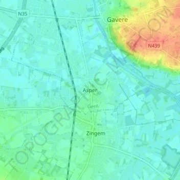
Name: Asper topographic map, elevation, terrain.
Location: Asper, Gavere, Gent, Oost-Vlaanderen, Vlaanderen, 9890, België (50.89353 3.63175 50.93353 3.67175)
Average elevation: 43 ft
Minimum elevation: 10 ft
Maximum elevation: 151 ft
Make a donation
Gear up for your next adventure:
As an Amazon Associate, this site earns from qualifying purchases at no extra cost to you.