
Make a donation
Gear up for your next adventure:
As an Amazon Associate, this site earns from qualifying purchases at no extra cost to you.
Natividade da Serra topographic map
Click on the map to display elevation.
Make a donation
Gear up for your next adventure:
As an Amazon Associate, this site earns from qualifying purchases at no extra cost to you.
Natividade da Serra
Natividade da Serra (meaning "the nativity of the mountain") is a municipality in the state of São Paulo in Brazil. It is part of the Metropolitan Region of Vale do Paraíba e Litoral Norte. The population is 6,642 (2020 est.) in an area of 833.37 km². The elevation is 720 m. The southern part is heavily forested and mountainous and there are few roads and tracks into the mountain. The hills and some mountains with farmlands dominate the rest of the municipality.
Make a donation
Gear up for your next adventure:
As an Amazon Associate, this site earns from qualifying purchases at no extra cost to you.
About this map
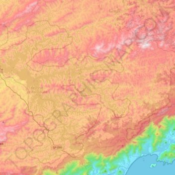
Name: Natividade da Serra topographic map, elevation, terrain.
Average elevation: 2,448 ft
Minimum elevation: 0 ft
Maximum elevation: 4,452 ft
Make a donation
Gear up for your next adventure:
As an Amazon Associate, this site earns from qualifying purchases at no extra cost to you.